Roc d'Orsay
mittel
Skitour
Navigieren
Navigieren
Hol diese Tour auf dein Handy
Karte
Roc d'Orsay
mittel
Skitour
3,39 km
QR-Code scannen und Navigation in der bergfex App beginnen
QR Code
Wandern & Tracking
Wandern & Tracking
Download für iOS
Download für Android

Roc d'Orsay

Distanz
3,39 km
Dauer
02:30 h
Aufstieg
658 hm
Seehöhe
1.280 - 1.938 m

This route starts from the lower station of the Roc d'Orsay cable car. Follow the pylons for the first kilometer. Depending on the snow conditions, take off your shoes and cross one or two paths. Then...


Beschreibung

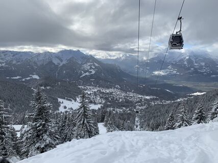
This route starts from the lower station of the Roc d'Orsay cable car.

Follow the pylons for the first kilometer.
Depending on the snow conditions, take off your shoes and cross one or two paths. Then join the Bouquetins track and follow it briefly then turn left and join the Tailles road. Cross the road and reach the Roc d'Orsay, an area well known to regulars and requiring care if the snow is icy.

Enjoy a break at the Roc d'Orsay restaurant and return to Villars via the pistes.

Wegverlauf
Roc d'Orsay
(1.976 m)
Gipfel
3,4 km
Le Roc 2000
(1.951 m)
Restaurant
3,4 km
Wegverlauf
Karte
Roc d'Orsay
mittel
Skitour
3,39 km
Roc d'Orsay
(1.976 m)
Gipfel
3,4 km
Le Roc 2000
(1.951 m)
Restaurant
3,4 km
Beschreibung

Lovely tour up to the Roc d’Orsay.

Technik
3 / 6
Kondition
3 / 6
Landschaft
4 / 6
Erlebnis
2 / 6
Beste Jahreszeit
Jan
Feb
Mär
Apr
Mai
Jun
Jul
Aug
Sep
Okt
Nov
Dez
Autor
Bereitgestellt von Paddy Jansen
Erstellt am 01. Januar 2022
1.619 Aufrufe
Logo
Tour teilen
Karte
Roc d'Orsay
mittel
Skitour
3,39 km
Fehler
Ein Fehler ist aufgetreten. Bitte versuche es erneut.
Zusatzinfos & Tipps
Tipps

Don’t leave any garbage behind, show consideration for the natural environment and the property owners of the land used! The forest is an undisturbed wildlife habitat, so please stay on the marked trails.

Noch keine Bewertungen
Bewertung schreiben

Bewertungen helfen anderen Usern bei der Auswahl ihres nächsten Abenteuers. Bewerte bitte nur die Tour, nicht das Wetter oder deine Jause.

Wähle einen der Sterne um die Tour zu bewerten
Schlechte Tour
Schwache Tour
Mittelmäßige Tour
Gute Tour
Ausgezeichnete Tour
bergfex logoHol dir den EinblickImmer live vor Ort mit über 9.500 Webcams. In der Touren App von bergfex siehst du als Pro-User jetzt zu vielen Touren die passenden Webcams. So kannst du dir direkt die aktuellen Bedingungen ansehen.
Wandern & Tracking

Wandern & Tracking

für iOS herunterladenfür Android herunterladen
Wandern & Tracking
Über 550.000 Tourenvorschläge, detailliertes Kartenmaterial und ein intuitiver Routenplaner machen die App zum Must-have für alle Naturbegeisterten.
Wandern & Tracking