La Croix des Chaux
mittel
Skitour
Navigieren
Navigieren
Hol diese Tour auf dein Handy
Karte
La Croix des Chaux
mittel
Skitour
5,97 km
QR-Code scannen und Navigation in der bergfex App beginnen
QR Code
Wandern & Tracking
Wandern & Tracking
Download für iOS
Download für Android

La Croix des Chaux

Distanz
5,97 km
Dauer
03:00 h
Aufstieg
699 hm
Seehöhe
1.363 - 1.996 m
Track-Download
Karte
La Croix des Chaux
mittel
Skitour
5,97 km

This itinerary, which requires a good physical condition, starts from the car park of Les Frasses. After carefully crossing the popular trail, go up along the edge of the forest for a few hundred meters,...


Beschreibung

This itinerary, which requires a good physical condition, starts from the car park of Les Frasses.

After carefully crossing the popular trail, go up along the edge of the forest for a few hundred meters, then enter the edge on the left.

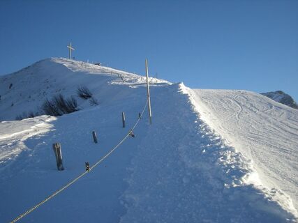
Go up and continue straight on, staying under the ski slope, then carefully cross this slope. Continue up along the Plan Métroz ski lift until you reach the Chaux cable car.

After carefully crossing the ski slope, go up to the left of the slopes, until the bend (telephone poles).

Continue to climb to the right along the piste and pass slightly above the arrival of the Sololeuvre chairlift. You have arrived.

Be careful, do not climb on the piste and do not stray from the markings.

Descend by the ski slope.

Wegverlauf
L'Étable
(1.462 m)
Restaurant
1,5 km
La Chaux-Ronde
(2.014 m)
Gipfel
5,7 km
Wegverlauf
Karte
La Croix des Chaux
mittel
Skitour
5,97 km
L'Étable
(1.462 m)
Restaurant
1,5 km
La Chaux-Ronde
(2.014 m)
Gipfel
5,7 km
Beschreibung

Physically demanding, but lovely tour up to the Croix des Chaux.

Technik
3 / 6
Kondition
4 / 6
Landschaft
4 / 6
Erlebnis
3 / 6
Beste Jahreszeit
Jan
Feb
Mär
Apr
Mai
Jun
Jul
Aug
Sep
Okt
Nov
Dez
Autor
Bereitgestellt von Paddy Jansen
Erstellt am 29. Dezember 2020
1.554 Aufrufe
Logo
Tour teilen
Karte
La Croix des Chaux
mittel
Skitour
5,97 km
Fehler
Ein Fehler ist aufgetreten. Bitte versuche es erneut.
Anreiseinformationen
Parken

From Barboleuse, take the route des Frasses to the car park.

From the car park, cross an alpine ski run for a few dozen metros (be careful) then arrive on a groomed run shared with cross-country skiers and pedestrians. You are at the start of the itinerary.

Zusatzinfos & Tipps
Tipps

Don’t leave any garbage behind, show consideration for the natural environment and the property owners of the land used! The forest is an undisturbed wildlife habitat, so please stay on the marked trails.

Noch keine Bewertungen
Bewertung schreiben

Bewertungen helfen anderen Usern bei der Auswahl ihres nächsten Abenteuers. Bewerte bitte nur die Tour, nicht das Wetter oder deine Jause.

Wähle einen der Sterne um die Tour zu bewerten
Schlechte Tour
Schwache Tour
Mittelmäßige Tour
Gute Tour
Ausgezeichnete Tour
bergfex logoHol dir den EinblickImmer live vor Ort mit über 9.500 Webcams. In der Touren App von bergfex siehst du als Pro-User jetzt zu vielen Touren die passenden Webcams. So kannst du dir direkt die aktuellen Bedingungen ansehen.
Wandern & Tracking

Wandern & Tracking

für iOS herunterladenfür Android herunterladen
Wandern & Tracking
Über 550.000 Tourenvorschläge, detailliertes Kartenmaterial und ein intuitiver Routenplaner machen die App zum Must-have für alle Naturbegeisterten.
Wandern & Tracking