


Tour de Creuse : Chambon sur Voueize > Châtelus Malvaleix


Over 400km of signposted cycle paths crossing the Creuse from east to west and from north to south are yours to explore!
The Tour de Creuse allows you to discover the truly remarkable, often little-known,...
Over 400km of signposted cycle paths crossing the Creuse from east to west and from north to south are yours to explore!
The Tour de Creuse allows you to discover the truly remarkable, often little-known, natural and cultural heritage of a French county packed with surprising, exceptional sights.
From the Creuse Artists’ Valley route to Vassivière Lake, going via the tapestry town of Aubusson, the Natural Reserve of the Étang des Landes, the medieval towns of La Souterraine, Bénévent l’Abbaye and Bourganeuf, the Abbey of Chambon sur Voueize and the thermal spa town of Évaux les Bains, you follow quiet country roads, the landscapes ceaselessly changing as you cycle along.
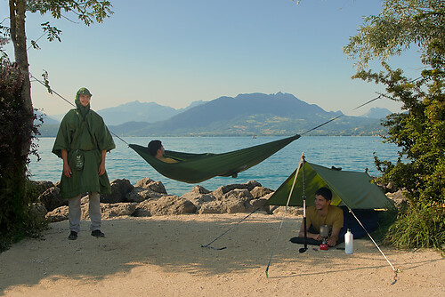
The Tour de Creuse à Vélo is all about great discoveries – you’ll never get bored, with such variety on offer. The route is suitable for all types of cyclists, from the most sporty to those out on a gentle family outing.
This stage begins at Chambon sur Voueize, with Its imposing 11th-century abbey church dedicated to St Valery and boasting exceptional Romanesque art. Follow in the literary footsteps of George Sand at Boussac, a majestic château atop its cliff. Then follow the northern link of the Tour de Creuse cycle route, to the village of Châtelus Malvaleix.


Taking you along quiet country roads, this 56km stage, with its 687m of cumulative elevation, may be relatively short but it is rather hilly. Be aware of the 5km climb after you leave the hamlet of Ventenat, taking you up to the village of Toulx Sainte Croix. All along the way, your route is indicated by green and white signage.
Link to Chambonchard (13km, 185m cumulative elevation)
There’s a link from Chambon sur Voueize, via Évaux les Bains, to the village of Chambonchard, on the border with the county of Allier.
Link to the Allier (11km, 114m cumulative elevation)
There’s a link from Boussac, via Saint Pierre le Bost, to the county of Allier.
A bike in good condition and well equipped helps to ensure your safety and that of other road users.
Before you leave:
Make sure that the bike is in perfect mechanical condition, not to mention the tires and brakes. Make sure that the bike is correctly adjusted to your body shape Wearing a helmet is strongly recommended Take a repair kit with you Remember that the Highway Traffic Act applies to cyclists in all circumstances Never drive more than two lanes at a time and pull into a single lane when traffic conditions require. Respect other users as you would like them to respect you Choose a route adapted to your physical abilities Inform your family and friends of your itineraryFind out about the weather conditions A first aid kit is not essential, but can be very useful Be informed and keep the emergency numbers. Respect the environment by not throwing your waste on the side of the road If you have to return at nightfall, make sure you see and also be seen.
Emergency number: 112
Creuse Confluence Tourist offices
Chambon sur Voueize office
Place Aubergier
23170 CHAMBON SUR VOUEIZE
Phone : + 33 (0)5 55 82 15 89
Boussac office
Place de l’Hôtel de Ville
23600 BOUSSAC
Phone: +33 (0)5 55 65 05 95
Beliebte Touren in der Nähe
L'étang des Landes
leichtWanderung7,07 kmRundtour um den Étang des Landes
mittelWanderung9,25 kmL'Etang de Landes LT1
leichtMountainbike5,25 kmBoucle à vélo N°19 : Echappée belle au pays de Jean de Brosse
schwerRadfahren28,0 kmBoucle à vélo N°25 : Sortie nature à la découverte du patrimoine local
leichtRadfahren20,3 kmBoucle à vélo N°23 : Circuit des panoramas
mittelRadfahren24,8 kmBoucle à vélo N°24 : Escapade nature autour de Boussac
mittelRadfahren26,5 kmBoucle à vélo N°30 : Découverte du patrimoine local
leichtRadfahren19,8 kmCircuit des lavoirs
leichtWanderung15,4 kmLa Brande de Landes
leichtWanderung11,2 km
Wandern & Tracking


Verpasse keine Angebote und Inspirationen für deinen nächsten Urlaub
Deine E-Mail-Adresse wurde in den Verteiler eingetragen.