


FFC cycling circuit no. 36: La Bonette par les 2 versants et le col de Vars


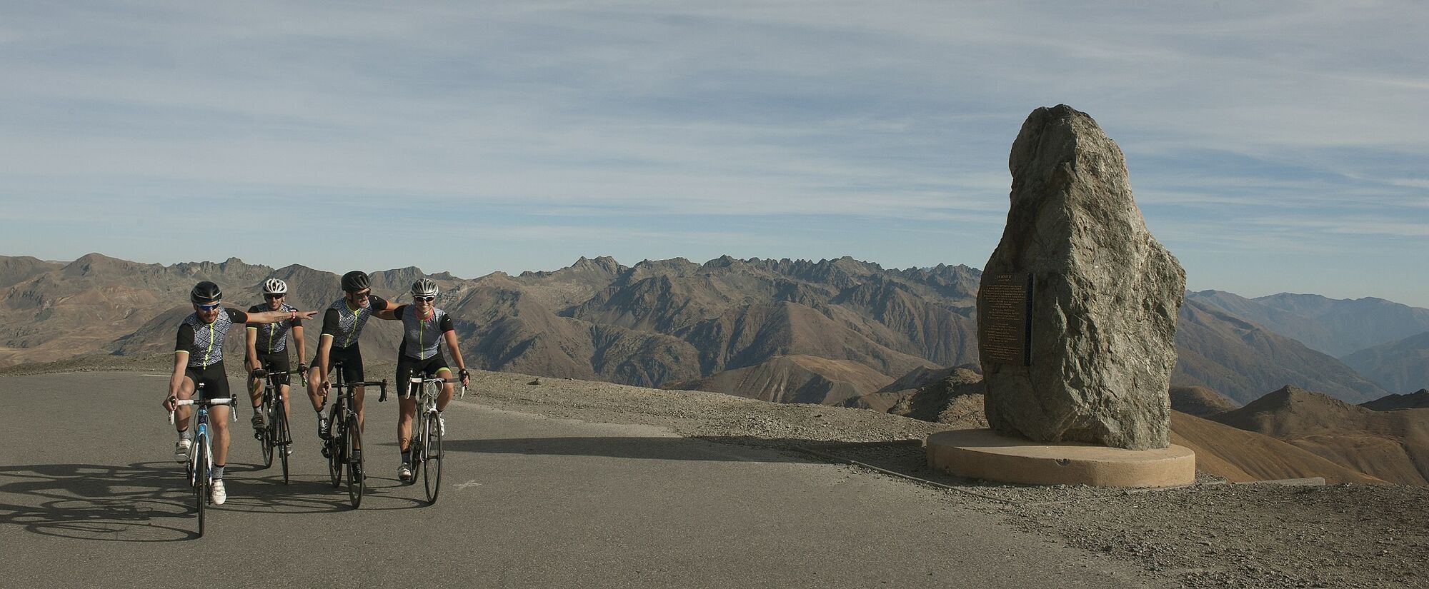
Crossing the Parc du Mercantour by road and linking the Vallée de la Tinée to the Vallée de l'Ubaye via the Col de la Bonette, classified as out of category during the last Tour de France, is a real personal...
Crossing the Parc du Mercantour by road and linking the Vallée de la Tinée to the Vallée de l'Ubaye via the Col de la Bonette, classified as out of category during the last Tour de France, is a real personal sporting feat in the image of the giants of the road. The route is recommended for seasoned cyclists, with 3 climbs and a vertical drop of almost 4,000 m, but it's also accessible to those who have already trained. On the day itself, they'll strive to climb at their own pace, saving their physical strength over time.
It's a great opportunity to enjoy the high mountain environment and discover the many military remains of the Second World War, including the Fourches camp, located on the southern slope and occupied by the military at the time.
All outdoor activities in the Nice Côte d'Azur region can be found at https://outdoor.nicecotedazur.org

The start sign is at the end of the bridge over the Tinée river, at the crossroads with the route de Saint-Dalmas and boulevard Maurice Rovery. This is also where you'll find the starting sign for the cime de la Bonette, announcing the difficulties: 25.5 km with average gradients over several km at 9%. From here, head towards the Col on the RM 2205, arriving at Km 4, at a place called Pont-Haut, which crosses the Tinée. At the end of the bridge, turn right onto the RM 64, wherethe road becomes narrower, heralding the entrance to the Mercantour Park. Once past the hamlet of Le Pra and the village of Bousiéyas, the road twists and turns as far as Camp des Fourches. The Col de Raspaillon heralds the arrival at the summit of the Col de la Bonette- Restefond (Km 24.6), and the itinerary invites cyclists to go straight over the pass to Jausiers without having to negotiate the steep slope of the cime de la Bonette. Indeed, there are still many difficulties ahead. The long descent of the Jausiers slope brings us to the intersection with the RD 900 (Km 46.6). From this junction, turn right towards Col de Vars. At the "Glizolles" crossroads, turn left onto the RD 902, direction Col de Vars, whose ascent is said to be 14.1 km long. But in fact, the real climb begins at Saint-Paul-sur Ubaye, as the road rises on the left, following the RD 902. The climb is not too difficult, even if the last 5 km are at an average of 9%. The view from the summit is remarkable. To return, take the road in the opposite direction to the Col de la Bonette on the north side.
Ja
Ja
-Wear an approved helmet
-Check the condition of your tires
-Carry a puncture repair kit
-Prefer at least one flashing LED light to be mounted on the seatpost so that you can be seen by other motorists.
-Don't overestimate your physical capabilities
-Find out about mountain weather and pass opening times before you set off.
-Respect the environment and other road users
Nice is served by the A8 "La Provençale" freeway, coming from Aix-en-Provence to the west and the border to the east.
Take Exit 52: Saint-Isidore
Direction Digne
Then take Route de la Tinée (RM 2205)
Bus routes can be found at: https://www.lignesdazur.com
Large Cartel parking lot, located on the RM 2205, close to the circuit start sign
Circuit for experienced cyclists - FFC color: black - ! COL DE LA BONETTE CLOSES IN WINTER
Beliebte Touren in der Nähe
- 5,0
eBike MNCA Etappe 2: St-Dalmas-Le-Selvage - St-Etienne-de-Tinée
mittelMountainbike43,2 km - 5,0
Chiappera- Spaziergang
leichtWanderung8,39 km Les lacs de vens
mittelWanderung18,9 kmRoute 'Hameau du Vivier' Provence-Alpes
mittelWanderung8,47 km- 5,0
Goldtoni - Alpenbogen A077 Refugium Campo-Bousieyas
mittelFernwanderweg34,1 km Radtour "La Bonette par la Moutière"
schwerRennrad51,0 km- 4,0
Col de Larche - Lac du Lauzanier, France
leichtWanderung13,7 km Wandeling vanaf Halte 2000 naar meer van Terres Plaines (Jausiers, Provence-Alpes)
mittelWanderung12,1 kmFFC-Mountainbike-Rundkurs n°37 : Col d'Anelle
schwerMountainbike11,2 km- 5,0
Col de la Bonette
schwerRennrad25,4 km
Wandern & Tracking


Verpasse keine Angebote und Inspirationen für deinen nächsten Urlaub
Deine E-Mail-Adresse wurde in den Verteiler eingetragen.