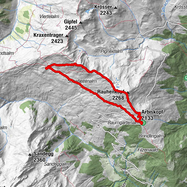
Melchboden - Arbiskopf - Rauhenkopf - Rastkogelhütte - Melchboden

Wanderung
Tourdaten
7,53km
2.012
- 2.329m
414hm
413hm
02:23h
- Kurzbeschreibung
-
Easy to average trail. With a little steep roped part after the Rauhenkopf.
- Schwierigkeit
-
mittel
- Bewertung
-
- Wegverlauf
-
Jausenstation Melchboden0,0 kmMelchboden0,1 kmArbiskopf (2.133 m)0,6 kmRauhenkopf (2.258 m)1,3 kmMitterwandskopf (2.280 m)2,0 kmKreuzjoch (2.338 m)3,0 kmRastkogelhütte4,2 kmMelchboden7,4 kmJausenstation Melchboden7,5 km
- Beste Jahreszeit
-
JanFebMärAprMaiJunJulAugSepOktNovDez
- Beschreibung
-
Easy start. Bit crowded but this gets better after the Arbiskopf.
Just before the ascent to Rastkogelhütte the is a short steep bit with ropes.
There is an option to continue to Kreuzjoch before ascending.
Don’t worry about eating too much at the hut, from the Rastkogelhütte back to Melchboden is a very easy trail. - Wegbeschreibung
-
Park your car at Melchboden on the Zillertaler Höhenstraße. Be advised, this is a toll road!
On the way back you can continue the high road though, and see some sights before going back. - Höchster Punkt
- 2.329 m
- Ausrüstung
-
Hiking shoes, sticks, water, sunscreen.
- Öffentliche Verkehrsmittel
-
There is a bus to Melchboden
- Parken
-
Ample parking at Melchboden
GPS Downloads


Weitere Touren in den Regionen
-
Mayrhofen - Hippach
1024
-
Hochfügen
321